Jamieson local newspapers
Local newspapers matching Jamieson
M
- Mansfield Courier »
The Mansfield Shire is located 180km north east of Melbourne and is a renowned tourism, farming and lifestyle precinct. (Mansfield, Merrijig, Mt Buller, Bonnie Doon, Jamieson, Woods Point, Kevington, Barjarg, Benalla, Euroa, Gaffneys Creek, Merton, Maindample, Barwite, Tolmie, Sawmill Settlement, Alpine Ridge, Macs Cove, Howqua, Goughs Bay, Howes Creek)
Jamieson, Victoria
|
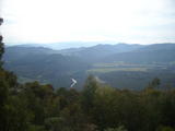
Just out of Jamieson, there is a spectacular view of the Jamieson Valley, looking down upon the winding Goulburn River shown here. Photo 23/04/2010 |
Jamieson lays south of Mansield, and is the pivotal junction of travelling south to Woods Point or west to Eildon. The Jamieson River and Goulburn River merge at the town. On the western outskirts, the road crosses the Goulburn and climbs into the mountains, on the 61km winding route towards the township of Eildon. |
Related links for Jamieson, VIC
In the neighbourhood:
Acheron (39km), Alexandra (40km), Bonnie Doon (39km), Buxton (40km), Eildon (21km), Howqua (8km), Kevington (7km), Maindample (35km), Mansfield (28km), Marysville (42km), Merrijig (27km), Mount Buller (33km), Snobs Creek (24km), Thornton (30km), Tolmie (42km), Woods Point (32km)


